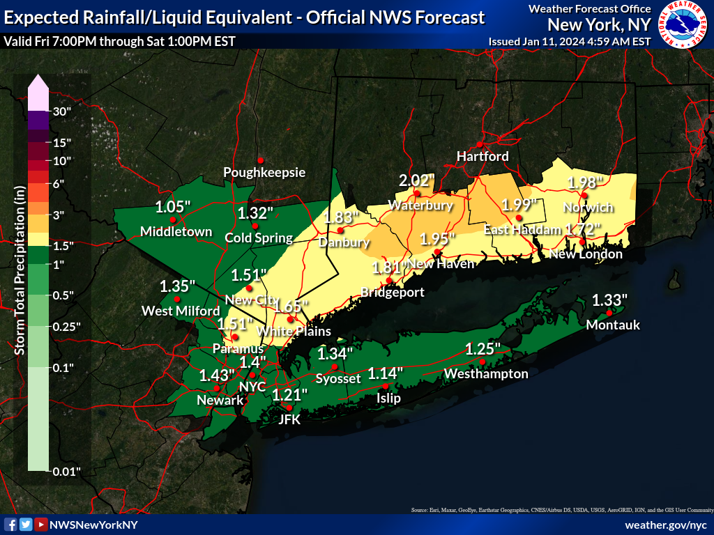
Next Rain Storm Friday Night 1/12


It helps here to add which town you are complaining about. SO has a well earned reputation for doing well with snow.

Maplewood. Still no sighting of DPW. We’ve lived here 15+ years. First time in memory town hasn’t treated street we live on before and during winter weather event,
DanDietrich said:
It helps here to add which town you are complaining about. SO has a well earned reputation for doing well with snow.


max_weisenfeld said:
I'd look at somewhere like New Paltz as a midpoint
 Thank you. Hope you can enjoy some of the white stuff before it's all slush!

Sunday, Jan 7th
Although the bulk of this storm is over, light snow and snow showers are likely to develop this morning, with total additional snowfall of around half an inch possible. Temperatures in the mid 30s today, dropping slightly below freezing overnight so watch out for icy patches Monday morning.
Monday should be dry and clear.
Tuesday afternoon rain develops as temps rise into the 40s. Heavy rain and high winds likely Tuesday night, with total rainfall between Tuesday and Wednesday of 2 to 3 inches possible. This is likely to again cause minor field and stream flooding as the ground is still saturated. winds could bring down branches and trees. Unseasonably warm temperatures hold through the end of the week.

HudsonBlue said:
Maplewood. Still no sighting of DPW. We’ve lived here 15+ years. First time in memory town hasn’t treated street we live on before and during winter weather event,
DanDietrich said:
It helps here to add which town you are complaining about. SO has a well earned reputation for doing well with snow.
My guess is the forecast was for only small amount of snow mixed with rain. The town put salt down on a notoriously icy spot in our neighborhood on Friday and it's completely gone. I think any salt pretreatment would have been washed away.
Sunday evening, Jan 7th
In case the "snow storm" caused you to lose track of the next act:
The NWS has issued a Flood Watch for Tuesday night. Widespread 2 - 3 inches of rain overnight onto saturated ground could lead local streams to overflow their banks causing local flooding
In addition, high winds are forecast overnight Tuesday into Wednesday

max_weisenfeld said:
Sunday evening, Jan 7th
In case the "snow storm" caused you to lose track of the next act:
The NWS has issued a Flood Watch for Tuesday night. Widespread 2 - 3 inches of rain overnight onto saturated ground could lead local streams to overflow their banks causing local flooding
In addition, high winds are forecast overnight Tuesday into Wednesday
Thanks, Max! We will prepare as best as we can.

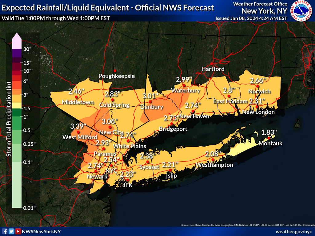
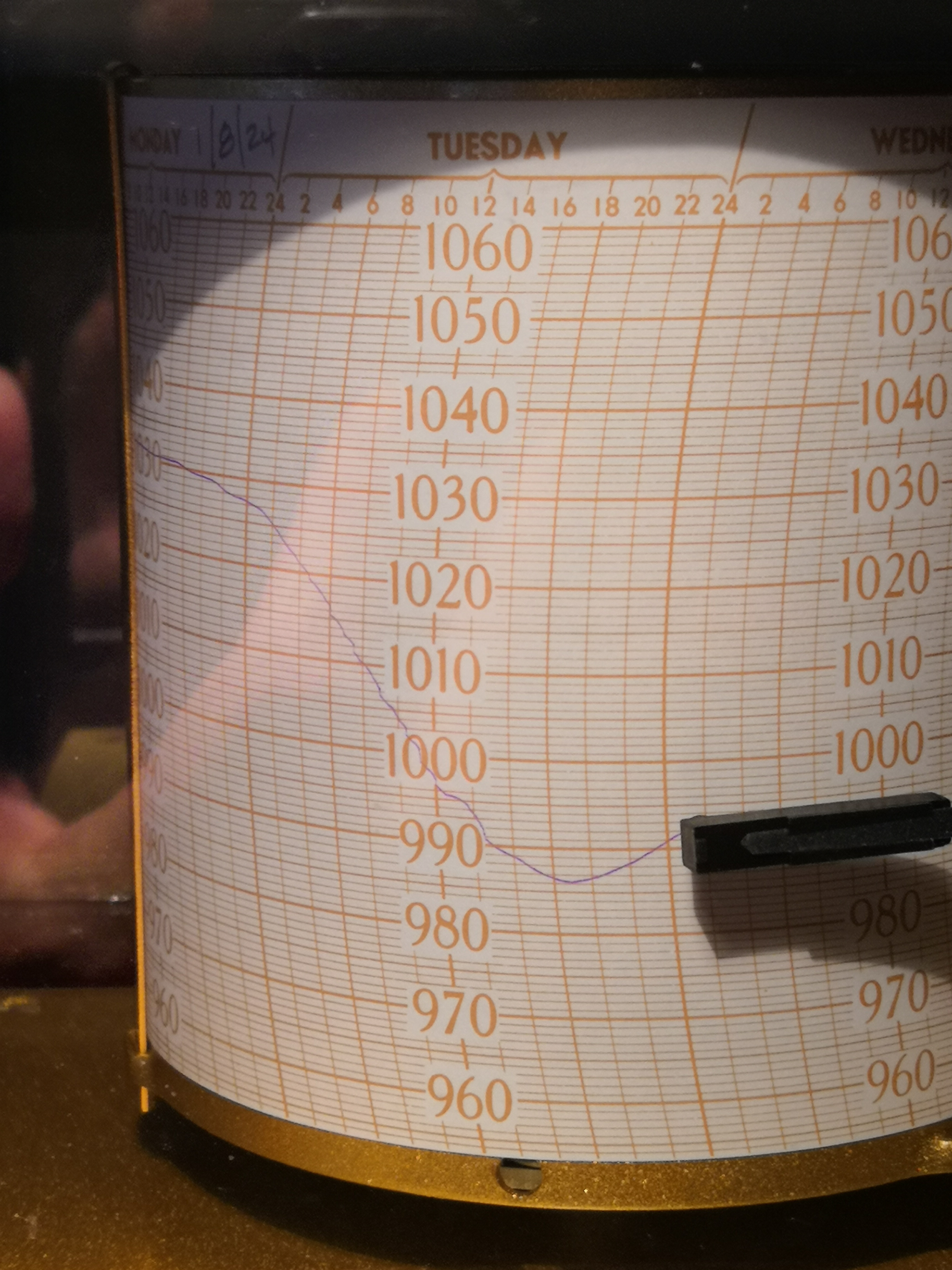
Monday Jan 8th 2024
Forecast is on track for heavy rain and wind Tuesday into Wednesday
A deep low pressure over the upper Midwest is likely to drag moisture from the gulf of Mexico through the region starting Tuesday. Light rain or snow during the day Tuesday should become all rain by late afternoon. Rain likely to become heavy after 5 pm and overnight, with a possible thunderstorm after midnight. Rainfall could reach an inch per hour rates at times overnight. Winds 25 - 30 mph with gusts into the 40s are forecast.
Total rainfall of 2 - 3 inches is quite possible.
Rain starts to taper off Wednesday but light rain could continue through early afternoon. Winds 15 - 20 with gusts to 30 probable throughout the day.
There is a NWS flood watch in effect from Tuesday afternoon through Wednesday night. Heavy rain on saturated ground could lead to small streams running over their banks and to some field and road flooding. Not Ida but could be as bad as last week was.
Clear and unseasonably warm weather follows Thursday and Friday, with more rain and wind possible Saturday.


Time to patch the hole in my basement floor.
Check all your downspouts. Look for any areas that water could collect next to your foundation. An errant pile of wet leaves can affect the normal pattern of drainage away from your house.
Unblock drains today, not when it’s already raining. We had that tragedy recently when someone was swept away and drowned after going out in a storm.
ETA That tragedy was in September of 2021. Remnants of Ida dumped 6-8”. I know this isn’t going to be on the same level but nevertheless be careful!!!

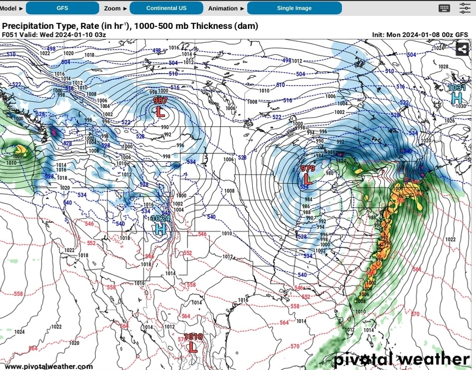
Some rather impressive model guidance today as far as precip goes. I do expect this to be a flooding event.
Wind gusts around 50 mph? There’s definitely gonna be power outages. I have a small generator I bought a few years ago, time to gas it up and start it.
everyone hyping this up, but the last few storms were a bust. you think this is the real deal?
boookwormnj said:
everyone hyping this up, but the last few storms were a bust. you think this is the real deal?
the last storm went pretty much exactly as forecast, but it really depends on what you call a bust. It may not impact you the same way it impacts someone on the opposite side of town. I expect gusty winds perhaps peaking around 40-50mph and approximately 2 inches of rain.
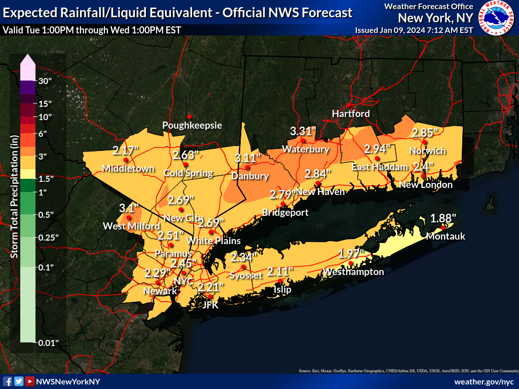
Tuesday Jan 9th
Forecast is on track for a powerful fast moving storm to pass through our area tonight with heavy rain and high winds.
The NWS has issued both a Wind Advisory and a Flood Watch for our area. The Wind Advisory runs from this evening through Wednesday morning and the Flood Watch runs through Wednesday afternoon.
After a brief drizzle or snow flurry this morning, rain should overspread the area starting in early afternoon. Rain becomes heavy after 5pm. Heavy rain continues until after midnight, moderate/light rain possible until dawn.
Winds should start picking up in the afternoon as well. Overnight, steady southeast winds of 20 - 25mph with gusts possible up to 50 mph. Winds continue 15 - 20 with 30 - 35mph gusts much of Wednesday.
Total rain fall of 2 - 2½ inches could happen in a fairly short 5 - 6 hour period with some periods of ½ inch or more per hour intensity. This heavy rain, falling onto saturated ground, could cause already swollen streams to overflow their banks, leading to localized flooding. Flooding might continue for several hours after the rain abates, be cautious and don't drive into possible flooded areas.
High winds could cause branches and trees to fall and might cause local power outages.
With winds in the mid levels (weather nerd jargon for 5000 to 8000 feet up in the sky) of over 100 mph, expect major air delays tonight.
Additional heavy rain probably expected Friday and Saturday, details tomorrow.
Flood Watch
Flood Watch
National Weather Service New York NY
418 AM EST Tue Jan 9 2024

NJZ002-004-006-103>108-NYZ067-069-092200-
/O.CON.KOKX.FA.A.0001.240109T2300Z-240110T2300Z/
/00000.0.ER.000000T0000Z.000000T0000Z.000000T0000Z.OO/
Western Passaic-Eastern Passaic-Hudson-Western Bergen-Eastern
Bergen-Western Essex-Eastern Essex-Western Union-Eastern Union-
Orange-Rockland-
418 AM EST Tue Jan 9 2024

...FLOOD WATCH REMAINS IN EFFECT FROM THIS EVENING THROUGH WEDNESDAY
AFTERNOON...

* WHAT...Flooding caused by excessive rainfall continues to be
  possible.

* WHERE...Portions of northeast New Jersey, including the following
  areas, Eastern Bergen, Eastern Essex, Eastern Passaic, Eastern
  Union, Hudson, Western Bergen, Western Essex, Western Passaic and
  Western Union and southeast New York, including the following
  areas, Orange and Rockland.

* WHEN...From this evening through Wednesday afternoon.

* IMPACTS...Excessive runoff may result in flooding of rivers,
  creeks, streams, and other low-lying and flood-prone locations.
  Creeks and streams may rise out of their banks. Extensive street
  flooding and flooding of creeks and rivers are possible.

* ADDITIONAL DETAILS...
  - A major storm system will impact the area tonight into
    Wednesday with heavy rainfall likely. Rainfall amounts of 2
    to 3 inches are forecast with localized higher amounts
    possible during this time. This combined with a snowpack
    across portions of the watch area along with saturated
    grounds will lead to rapid runoff into area rivers and
    streams.
  - http://www.weather.gov/safety/flood

PRECAUTIONARY/PREPAREDNESS ACTIONS...

You should monitor later forecasts and be alert for possible Flood
Warnings. Those living in areas prone to flooding should be prepared
to take action should flooding develop.
Wind Advisory
URGENT - WEATHER MESSAGE
National Weather Service New York NY
349 AM EST Tue Jan 9 2024

CTZ005>007-NJZ002-004-103>108-NYZ067>070-092200-
/O.CON.KOKX.WI.Y.0001.240109T2300Z-240110T1100Z/
Northern Fairfield-Northern New Haven-Northern Middlesex-
Western Passaic-Eastern Passaic-Western Bergen-Eastern Bergen-
Western Essex-Eastern Essex-Western Union-Eastern Union-Orange-
Putnam-Rockland-Northern Westchester-
349 AM EST Tue Jan 9 2024

...WIND ADVISORY REMAINS IN EFFECT FROM 6 PM THIS EVENING TO 6 AM
EST WEDNESDAY...

* WHAT...Southeast winds 20 to 30 mph with gusts up to 55 mph
  expected.

* WHERE...Portions of southern Connecticut, northeast New Jersey
  and southeast New York.

* WHEN...From 6 PM this evening to 6 AM EST Wednesday.

* IMPACTS...Gusty winds could blow around unsecured objects.
  Tree limbs could be blown down and a few power outages may
  result.

PRECAUTIONARY/PREPAREDNESS ACTIONS...

Use extra caution when driving, especially if operating a high
profile vehicle. Secure outdoor objects.

Won’t it be easier if we had one specific thread for the weather related stuff? Just asking.
Jaytee said:
Won’t it be easier if we had one specific thread for the weather related stuff? Just asking.
Note the headline. There's a specific storm thread. Then there's a general "weather banter" thread.
yahooyahoo said:
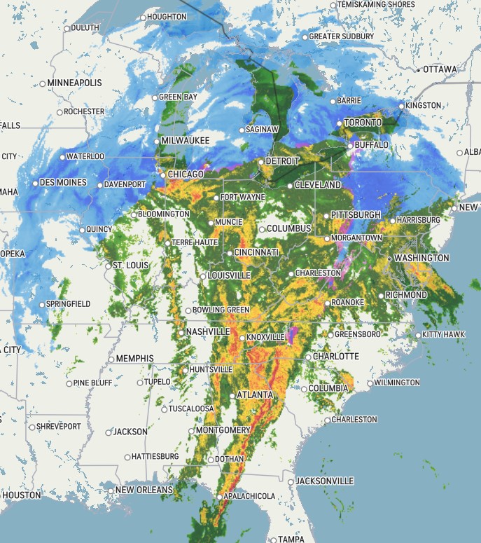
The size of this storm is impressive.
Was just thinking this — I can’t remember a system with such huge precip shield off the top of my head. It’s very impressive. there have also been quite a few severe wind/tornado reports in the Deep South yesterday and today.
Soil moisture is certainly higher than average, which combined with the cold temps won't help
https://www.cpc.ncep.noaa.gov/products/Soilmst_Monitoring/US/Soilmst/Soilmst.shtml#
Usual links to the gauges:
Rahway At Springfield: https://dashboard.waterdata.usgs.gov/api/gwis/2.1/service/site?agencyCode=USGS&siteNumber=01394500&open=194584
West Branch of the Rahway in Millburn: https://dashboard.waterdata.usgs.gov/api/gwis/2.1/service/site?agencyCode=USGS&siteNumber=01394000&open=194581
East Branch of the Rahway in Maplewood: https://dashboard.waterdata.usgs.gov/api/gwis/2.1/service/site?agencyCode=USGS&siteNumber=01393890&open=194573
East Branch of the Rahway at the Maplewood/Millburn border: https://dashboard.waterdata.usgs.gov/api/gwis/2.1/service/site?agencyCode=USGS&siteNumber=01393895&open=194577
Water levels at selected locations in NYC: https://dataviz.floodnet.nyc/
Wed Jan 10th 2024
While the rain is mostly ended this morning (still possible to get a shower or two) the wind is likely to pick back up again this afternoon.
The NWS continues the Flood Warning for small stream flooding. The East Branch of the Rahway River [aka the Memorial Park Brook] was still above flood stage at 7:00 this morning, but falling.
The NWS also continues the Wind Advisory, with steady winds this afternoon reaching the low 20mph range and gusts in the high 40s.
Wind and flooding should abate overnight.
We expect one and very possibly two more of these storm systems before this set-up is over. The next is probably a rain storm over the coming weekend, likely focused on Saturday. Then we are looking at what might be snow around MLK Day, although it is too early to say with any certainty.

Komarovsky said:
Soil moisture is certainly higher than average, which combined with the cold temps won't help
https://www.cpc.ncep.noaa.gov/products/Soilmst_Monitoring/US/Soilmst/Soilmst.shtml#
Usual links to the gauges:
Rahway At Springfield: https://dashboard.waterdata.usgs.gov/api/gwis/2.1/service/site?agencyCode=USGS&siteNumber=01394500&open=194584
West Branch of the Rahway in Millburn: https://dashboard.waterdata.usgs.gov/api/gwis/2.1/service/site?agencyCode=USGS&siteNumber=01394000&open=194581
East Branch of the Rahway in Maplewood: https://dashboard.waterdata.usgs.gov/api/gwis/2.1/service/site?agencyCode=USGS&siteNumber=01393890&open=194573East Branch of the Rahway at the Maplewood/Millburn border: https://dashboard.waterdata.usgs.gov/api/gwis/2.1/service/site?agencyCode=USGS&siteNumber=01393895&open=194577
Water levels at selected locations in NYC: https://dataviz.floodnet.nyc/
I took a look at that this morning and the reader by me registered a crest of 7.26 feet at midnight last night. So it took 9.5 hours to go from 2ft to 7 1/4ft last night.
In comparison, at the same station during Ida, the river went from 2ft at 6pm to 11.37ft by 9.45pm.
That's why those of living near that river have flashbacks and palpitations, and have to stay awake until it stops like the rain is Freddy Krueger every time we see "heavy rain" next to Max's name here.
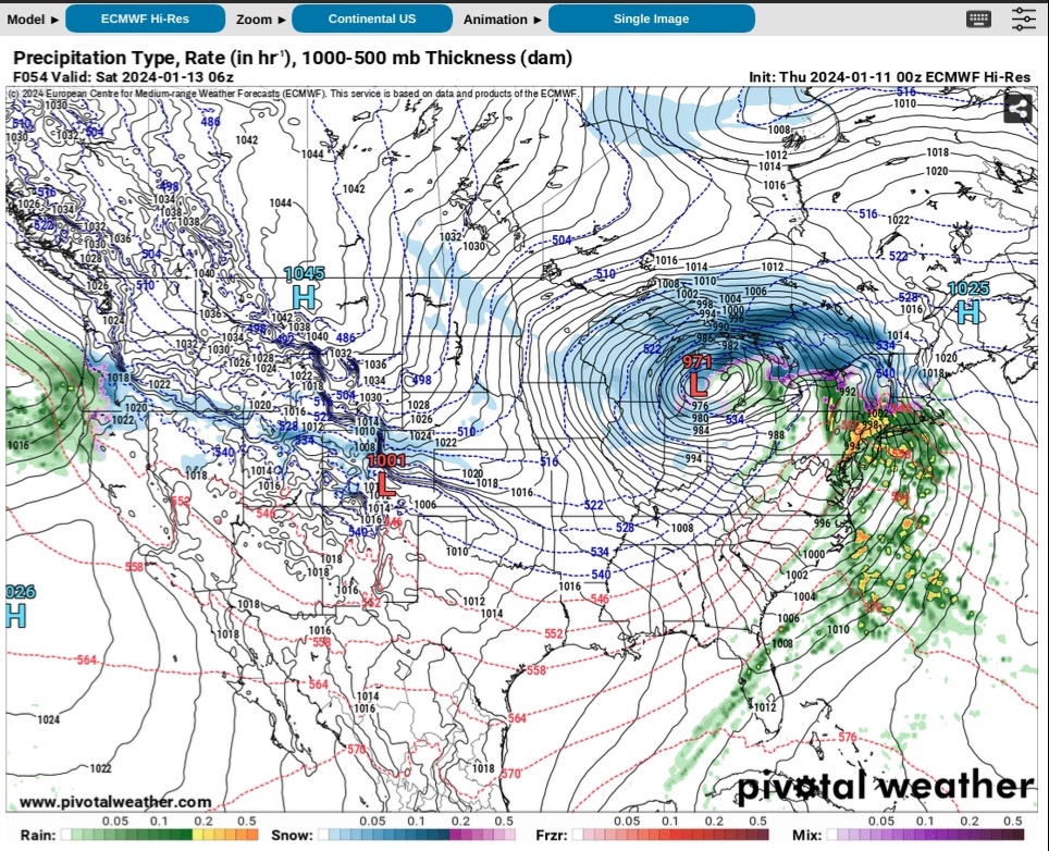
Thursday Jan 11 2024
Yet another low pressure system is forecast to pass through the area Friday night (tomorrow) into Saturday.
Similar to the storm earlier this week but not quite as powerful, a rain and wind event will come through this weekend. Rain will pick up, likely after 7 pm, heavy at times, and continue through Saturday early morning, becoming more moderate after midnight. Total rainfall of 1 to 2 inches likely. Wind 15 - 20 with gusts in the 30s likely throughout the period, and the wind probably will continue throughout the day Saturday, Saturday night, Sunday, and possibly into Sunday night.
Temps continue unseasonably warm during this period, becoming colder Sunday night into Monday.
The next system on the models is early next week, possibly Tuesday or Wednesday. At this point, 140+ hours out, there is still significant disagreement in the global models over strength and timing, but there is a strong signal that that one could be snow.

Rentals

For Sale
-

2007 Honda Fit $4,400
More info -

REVO luggage $100
More info


Can anyone explain why on earth the town didn’t salt prior to the storm hitting? With the taxes we pay, I’m fuming. Haven’t seen a single DPW vehicle on our street all day. Completely inexcusable.