Last week's snow thread. New thread above ^^

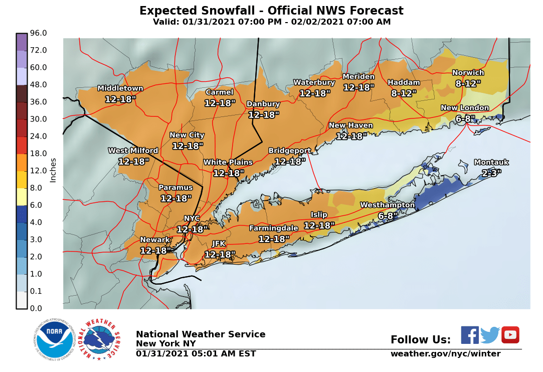
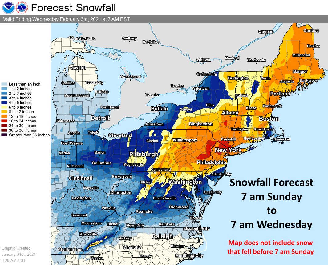
I should add that the NWS is still quite a bit more bullish on this one than I am. The official forecast is 12 - 18"


You can't read the label on the bottleneck but it says "02-02-02".


It’s looking like this storm will come in 3 stages. From Sunday night to Tuesday afternoon we might get more than 12 inches of snow. Total.


max_weisenfeld said:
I should add that the NWS is still quite a bit more bullish on this one than I am. The official forecast is 12 - 18"
I’m getting very much on board with them.
Yeah, and the 00z NAM snows for 36 hours straight, too.
WxNut2.0 said:
I have become very bullish on this system tonight.
max_weisenfeld said:
Yeah, and the 00z NAM snows for 36 hours straight, too.
WxNut2.0 said:
I have become very bullish on this system tonight.
If the NAM3 is correct — a big if — we won’t forget this storm for a long time.

I may have to reschedule my colonoscopy that is scheduled for Tuesday. I'll call Monday before doing the prep. TMI

cramer said:
I may have to reschedule my colonoscopy that is scheduled for Tuesday. I'll call Monday before doing the prep. TMI
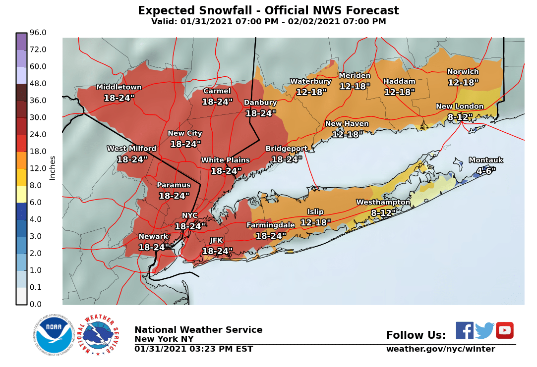
NWS NYC upgrades is to a Winter Storm warning and comes in pretty hot with this forecast package: https://www.weather.gov/media/okx/01312021am_socialmedia.pdf.
Mentions of possible blizzard conditions and 16” in Newark. I am very much in agreement with this analysis.
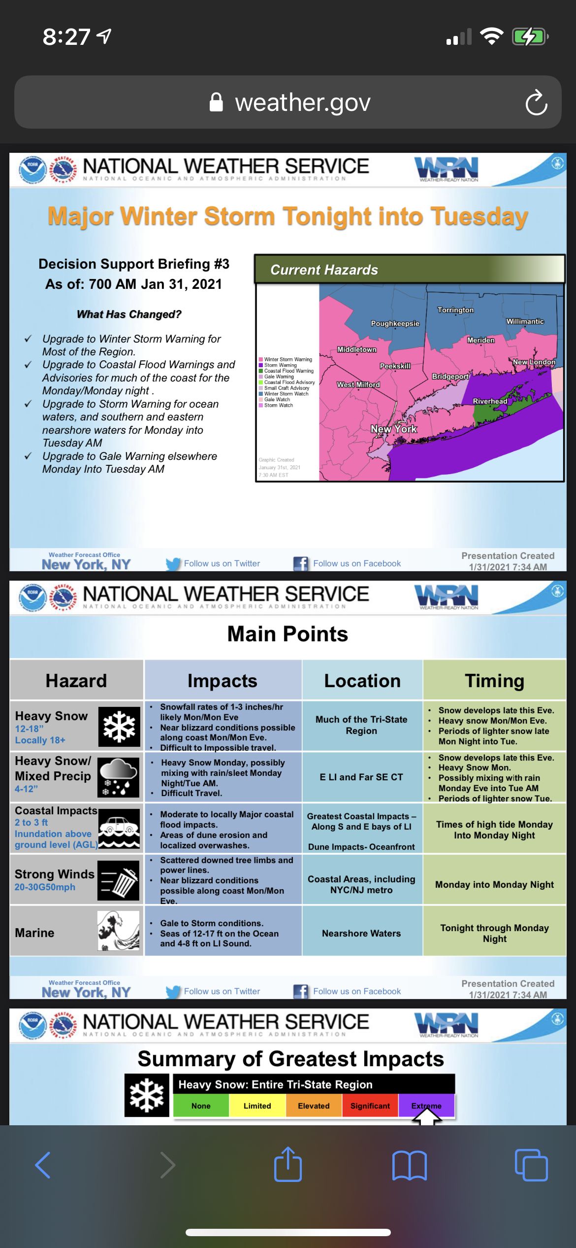
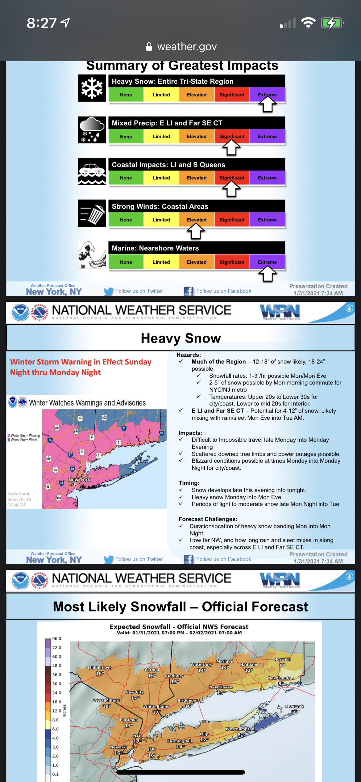

MAJOR WINTER STORM TONIGHT, 1/31, THROUGH EARLY TUESDAY 2/2
The national weather service has issued a Winter Storm Warning for our area from 7:00pm this evening until 6:00am Tues for heavy snow and blowing and drifting snow.
The forecast is currently at 12" - 18" with possible upside up to 2 feet if heavy banding occurs.
Snow starting after sunset with light snow until after midnight tonight. By the wee hours snow becomes moderate. Steady snow all day Monday with heavy snow possible for several hours Monday afternoon. Blowing and drifting likely Monday afternoon and Tuesday evening. Snow continues through the early morning hours Tuesday. It is quite possible snow showers will continue throughout the day Tuesday, with a possible 1" - 3" additional snow.
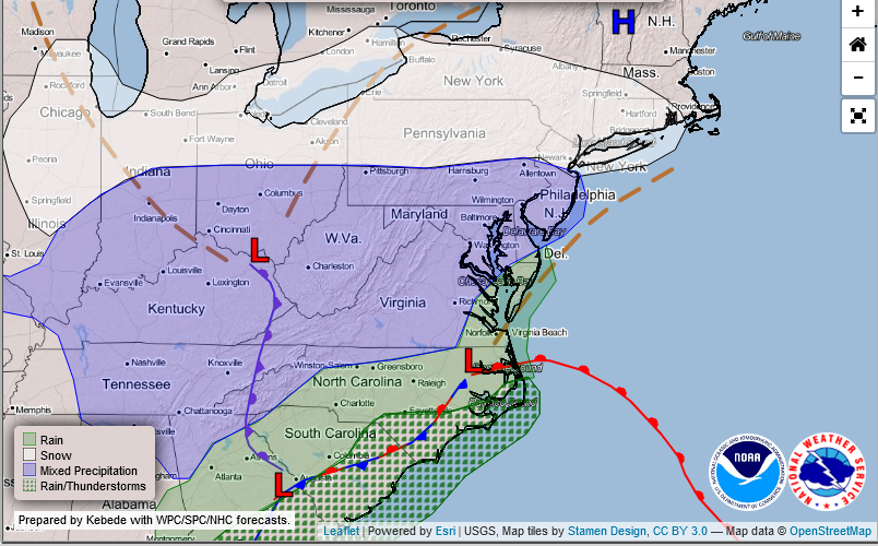
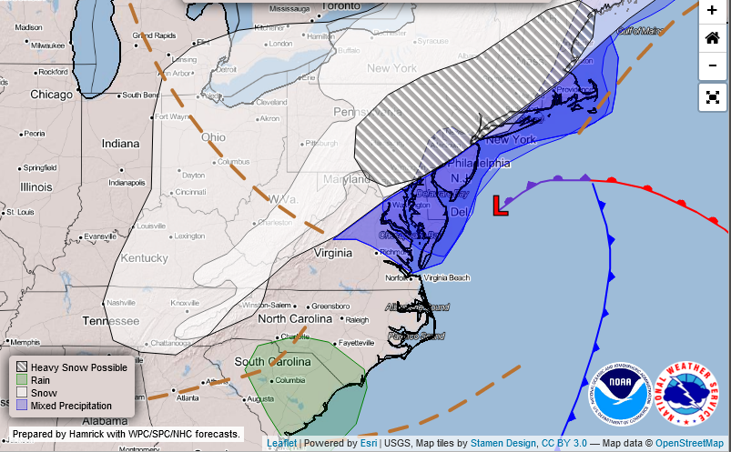
This will be a long duration storm. Although there will likely be some periods of heavy snow Monday afternoon, the really high totals are due as much to the fact that there could easily be 36 - 42 hours of snow. the American models (primarily using GFS & NAM) are cold enough for the event to be all snow, with the NAM in particular showing the possible upside beyond forecast amounts.
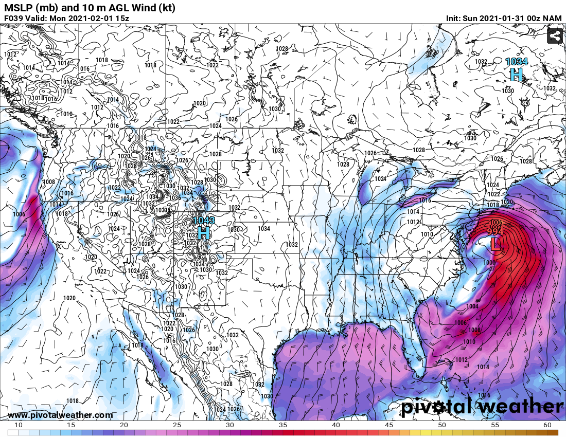
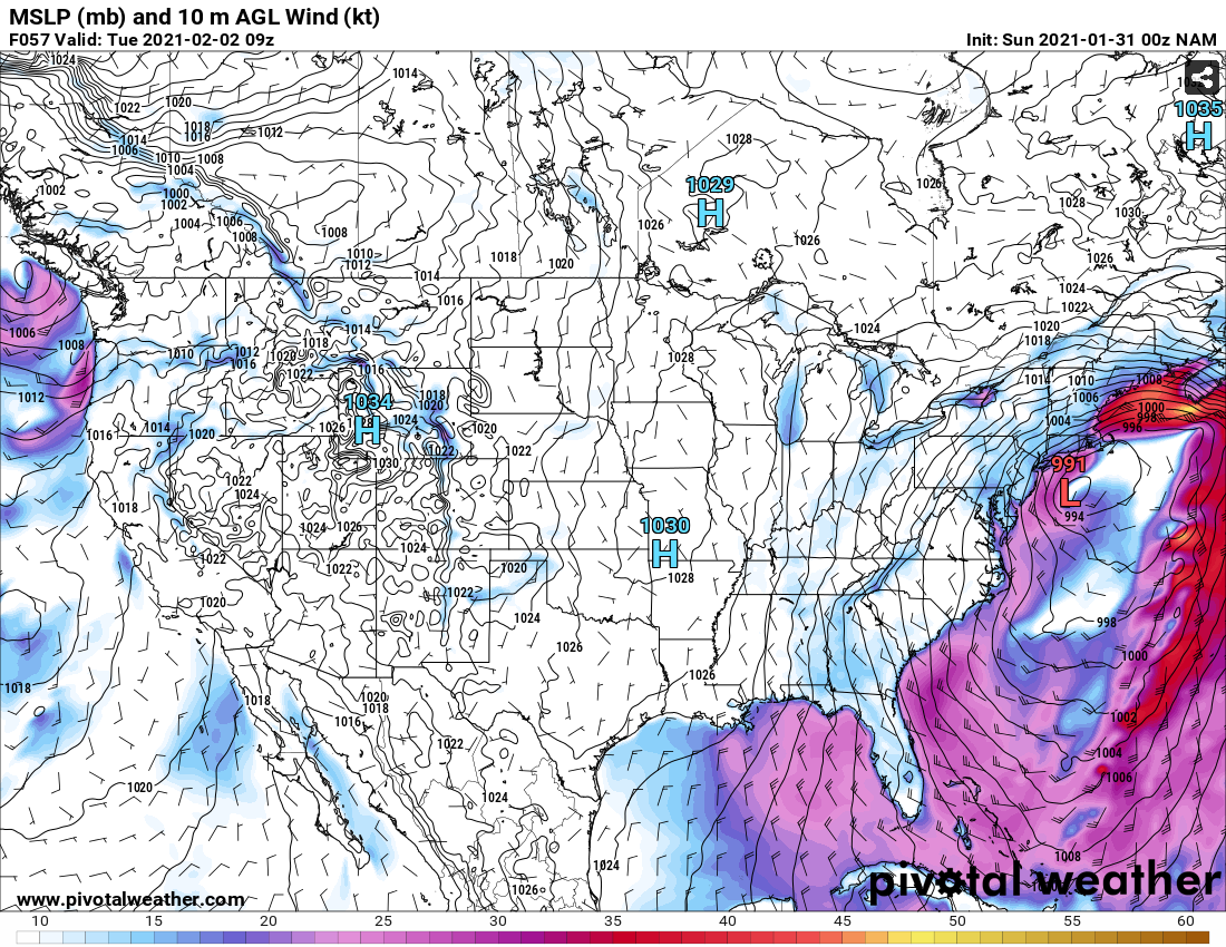
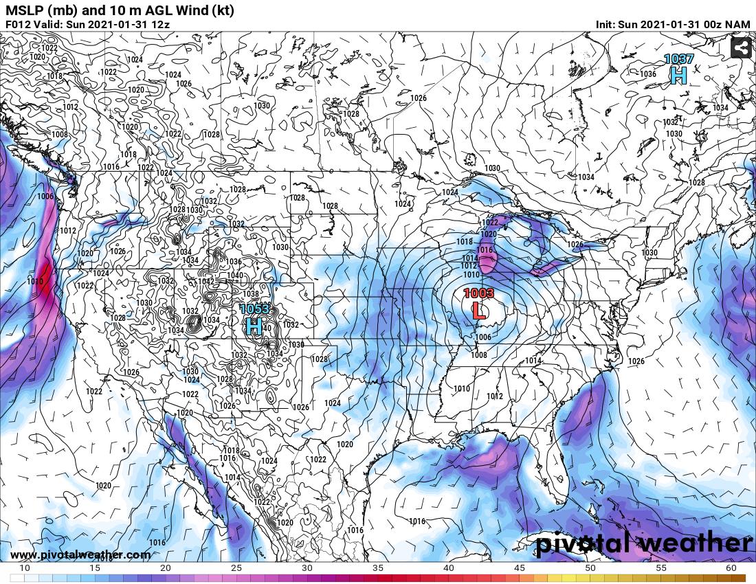
I am attaching 3 screenshots of the GFS model output from this morning. In the first, you see the location of the Pacific energy part of this storm currently south of Chicago. The next two are Monday at 10:00am and Tuesday at 4:00am showing the storm center in both east of Atlantic City. The upshot is that, and this sort of solution has been dominant in the models for over a day now, this storm sits stalled with us in the sweet spot for snow for almost 24 hours. While this storm is not a huge "cyclo-bomb" the long duration and steady below-freezing temperatures tend to support a great deal of snow accumulation.
Also, as the NWS says, this storm is likely to make travel difficult or impossible for much of Monday. The long duration also implies that crew exhaustion may slow cleanup on Tuesday as crews will have been out for 42 hours by Tuesday afternoon if the snow continues that long.
Winter Storm Warning
URGENT - WINTER WEATHER MESSAGE
National Weather Service New York NY
344 AM EST Sun Jan 31 2021

NJZ002-004-103-105-107-312045-
/O.UPG.KOKX.WS.A.0001.210201T0500Z-210202T1100Z/
/O.NEW.KOKX.WS.W.0001.210201T0000Z-210202T1100Z/
Western Passaic-Eastern Passaic-Western Bergen-Western Essex-
Western Union-
344 AM EST Sun Jan 31 2021

...WINTER STORM WARNING IN EFFECT FROM 7 PM THIS EVENING TO 6 AM
EST TUESDAY...

* WHAT...Heavy snow expected. Total snow accumulations of 14 to
  18 inches. Winds gusting as high as 35 mph.

* WHERE...Western Passaic, Eastern Passaic, Western Bergen,
  Western Essex and Western Union Counties.

* WHEN...From 7 PM this evening to 6 AM EST Tuesday.

* IMPACTS...Travel could be very difficult to impossible. The
  hazardous conditions could impact the morning and evening
  commute.

PRECAUTIONARY/PREPAREDNESS ACTIONS...

If you must travel, keep an extra flashlight, food, and water in
your vehicle in case of an emergency.

Check local Department of Transportation information services for
the latest road conditions.

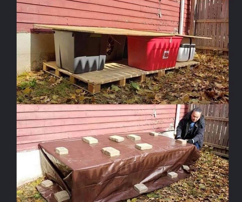
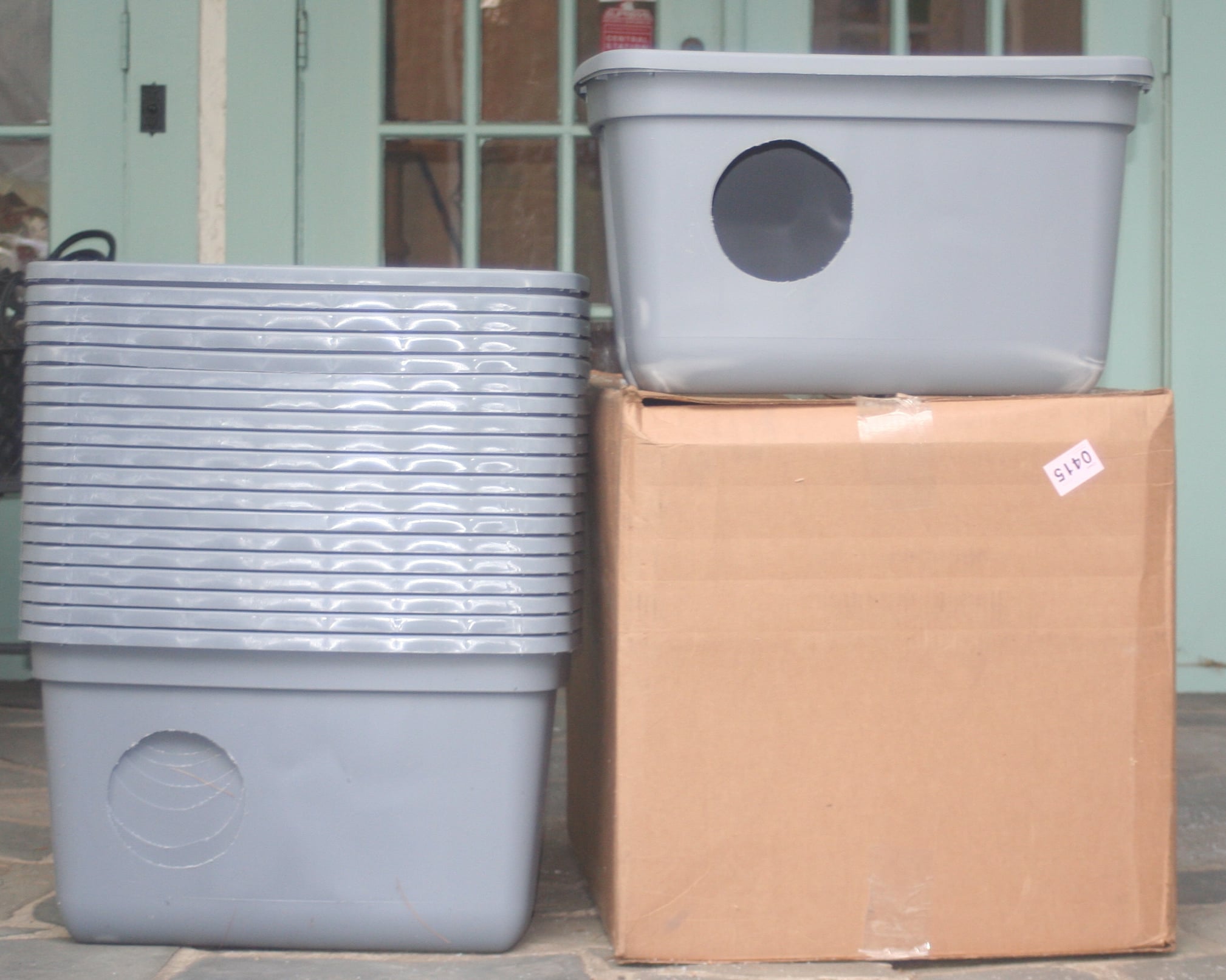
Most of us who are directly or indirectly involved with the care of feral cat colonies are sad but prepare as best we can for these events.
Some friend who live in Newark, Irvington, and East Orange, manage as many as 13 colonies each that they travel to and feed daily. In preparation those of us who either support them as rescues by taking into our groups the kittens and the friendlies that are abandoned build and donate shelters.
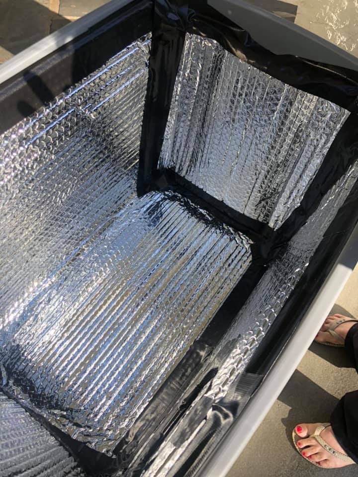
I've made 20 this year, but the real heroes are the architects who place them on palletes, cover them with plywood, then tarps weighted with pavers. The shelters are each insulated. Mine are plastic storage totes, with a 5" hole cut, lined with Reflectix, taped with Gorilla Tape and stuffed with straw. Great project for kids stuck at home. Free styrofoam containers can be used and obtained from Petco who tosses them out after aquarium deliveries. Plenty of videos online.
Wet food freezes quickly so the cats eat when the feeder comes. Dry is left and water. With an event such as this the feeders will be home frantic that they can not get to their colonies.
If anyone in the future wants to take a feral from a dangerous location and give them a shelter in their yard or garage, it only takes 4 weeks to acclimate a spayed or neutered, vaccinated feral, to a new location.
Or how about feeding a colony once a week to give a caretaker a break?
Apologies for the thread drift.
Below my friend setting up. My houses donated to colonies in Irvington.
WxNut2.0 said:
I buy this
Where do you get that graphic? I have been looking all over the NOAA site for it. Do you have a link?

Boy this sure escalated quickly. I hadn't heard the latest forecast before heading out to Shoprite. No wonder it was such a zoo.
I'm not really an expert on terminology, but it looks like we're on the line between a "humdinger" and a "walloping".

max_weisenfeld said:
WxNut2.0 said:
I buy this
Where do you get that graphic? I have been looking all over the NOAA site for it. Do you have a link?
https://www.weather.gov/nerfc/snow
ETA: I wanted to see if Google would find it. I put in "noaa nws snow forecast northeast" and it came right up.
So, I’m driving to Delaware to pick up Daughter today. How much earlier is it hitting there? I don’t mind driving in snow so long as there’s some visibility.
marylago said:
max_weisenfeld said:
WxNut2.0 said:
I buy this
Where do you get that graphic? I have been looking all over the NOAA site for it. Do you have a link?
https://www.weather.gov/nerfc/snow
ETA: I wanted to see if Google would find it. I put in "noaa nws snow forecast northeast" and it came right up.
Thanks
shanabana said:
So, I’m driving to Delaware to pick up Daughter today. How much earlier is it hitting there? I don’t mind driving in snow so long as there’s some visibility.
Go now. Come right back.
Could start lightly snowing within the hour. Moderate snow could start as early as early afternoon.
max_weisenfeld said:
Go now. Come right back.
Could start lightly snowing within the hour. Moderate snow could start as early as early afternoon.
Ok, gotcha. Thanks!
Perhaps a slightly under talked about aspect of this is the wind. I would be relatively surprised if we didn’t get a blizzard warning out of this. I’m very high on this event.
Nary a peep from SOMSD. Do you think there will be in-person instruction tomorrow?

Sunday evening update (1/31)
The only real significant change is the NWS has upped their forecast to 18" - 24"
There is good consensus among all the models that we are in for a long snow. The GFS, NAM, and Euro all show an all-snow event from now through Tuesday, with the heaviest snow falling Monday afternoon. There are indications that we could see some heavy banding Monday afternoon. If that occurs, expect some period where snow falls at 2" - 4" per hour.
Winds, although blustery, are very unlikely to rise to blizzard standards in MAPSO, with steady winds of 20 - 30 mph and gusts in the mid-30s (highest winds Monday afternoon).
There is still some uncertainty as to when snow ends, but all agree that it is likely at least through midnight Monday night, and the American models, which seem to have a better handle on this storm, showing snow on and off most of the day Tuesday, although accumulation Tuesday likely to be only another 2" - 3".
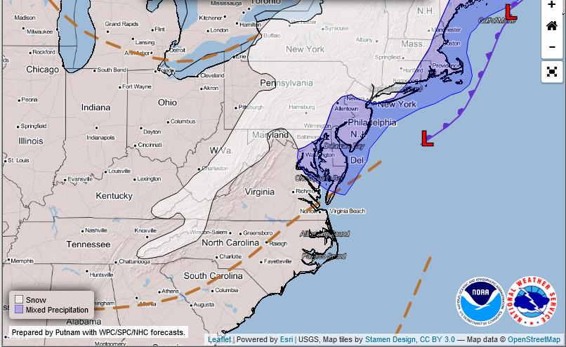
Snow map below, and NWS maps showing the movement of the lows. Today there are three centers to the system, with one in the Ohio Valley, one in coastal North Carolina, and a third in the south. The coastal low is what is snowing on us now. Tomorrow, the three have phased into one low parked off the New Jersey shore, and it is snowing heavily. By Tuesday the system is slowly moving east and then north towards New England. Although the Tuesday map shows us near an area of mixed precipitation, I think that if it gets that warm here it will have stopped precipitating.

Sponsored Business


Promote your business here - Businesses get highlighted throughout the site and you can add a deal.


Winter Storm Watch