Summer Is Acomin' In (aka the weather thread))


Wed June 4th
Today, sunny, warm, Air Quality Alert for ozone. Hazy sun today as the wildfire smoke stays high in the atmosphere but the sun creates ozone levels that could be unsafe for sensitive individuals. High in the upper 80s
Thursday warm and sunny, high upper 80⁰s
Friday starts out sunny but some clouds roll in in the afternoon, high mid 80⁰s
Saturday showers likely and perhaps a thunderstorm in the afternoon, highs in the upper 70⁰s
Sunday looks dryer and mostly sunny, high in the upper 70⁰s
Overnight lows in the 60⁰s throughout the period
Friday June 6th
Last day of the heat today as a mild low pressure moves through this afternoon and evening bringing some clouds and a slight chance of showers or a thunderstorm. Although a thunderstorm is not likely here, if one passes through the rain could be heavy for a period. Increased clouds should limit the development of ozone and hopefully bring an end to the air quality alerts for the time being. High upper 80⁰s low mid 60⁰s
Saturday likely showers and perhaps a thunderstorm, mostly in the afternoon, mostly cloudy and cooler. High near 80⁰ low in the mid 60⁰s
Sunday slight chance light showers, high upper 70⁰s, low lower 60⁰s
Monday cloudy, slight chance of showers in the morning, upper70⁰s/low 60⁰s
Tuesday rain likely
Monday June 9th
Light showers taper off as the day goes by, high upper 60⁰s
Tuesday, showers, possibly heavy at times, likely through the afternoon, then clearing. High mid 70⁰s, humid
Wed and Thurs, mostly clear, high mid to upper 80⁰s
Friday chance showers, weekend showers and coooler


Ear worm! Now I’m singing the entire Renaissance song since seeing the title of this thread.
Wed June 18th
Foggy this morning take care on the roads
Today, fog gives way to showers, high in the lower to mid 80⁰s, humid, isolated showers might get heavy
Tomorrow starts out with mixed clouds and sun, humid, warm, then showers likely and a chance of thunderstorms, possibly a severe storm with gusty winds the main threat, high in the mid to upper 80⁰s with the heat index over 90⁰
Friday things clear up and we should have a nice, albeit a bit humid, sunny day. High mid 80⁰s
Saturday mostly sunny, hot and humid, high upper 80⁰s with a heat index over 90⁰
Right now Sunday looks dry, hot, and humid but there are hints of instability that might develop so watch for afternoon showers that might be added to the forecast
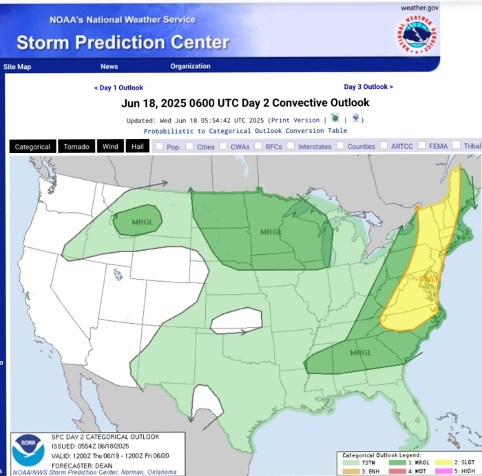
Image shows the Storm Prediction Center's outlook for severe weather for tomorrow with our area in the yellow 'slight' risk area for a severe thunderstorm
Thurs June 19
The NWS has issued a Severe Thunderstorm Watch until 9:15 pm tonight for the entire area
Small storms are moving through the region now (2:00pm). Although there are no *severe* storms in the area at the moment, conditions are becoming conducive to their development this afternoon and especially this evening.
A watch means conditions are conducive to development; ideally a warning would be issued as a storm approaches so if you're outside keep your phone handy. Please do NOT depend on me for timely warnings, you should arange to get those directly
Chance of thunderstorms this afternoon, and a possibility of severe thunderstorms. The main concerns should a severe storm develop would be high gusty winds, also possible heavy rain, hail, and road and field ponding

It looks like we’ve been moved from a watch to a warning for the next 45 minutes or so … good time to get yourself and pets inside.
Family members, well, that’s up to you.

I heard a rumor of a nearby tornado. Friends from out of town texted to ask if we were okay. Can anyone confirm this? I can’t find anything online.
Friday June 20th
Hot dry weather period begins
Today, warm, gathering clouds this afternoon and evening, high mid 80⁰s, low in the upper 60⁰s
Saturday hot, mostly clear, high near 90⁰, low near 70⁰
Sunday through Tuesday, very hot, highs in the upper 90⁰s to near 100⁰, humid. Lows in the mid to upper 70⁰s provide little relief. This should be advisory level heat, please take appropriate caution
There is a very slight possibility of an isolated thunderstorm throughout the period

Lightning hit real close to us yesterday afternoon. My wife was outside gardening. Sheesh.

How much rain did we get yesterday? I’m away and hoping we didn’t get a flooded basement.
bub said:
Lightning hit real close to us yesterday afternoon. My wife was outside gardening. Sheesh.
Around 4:22 yesterday? I was in my car and there was a lightning flash and a huge clap of thunder almost simultaneously.

Just saw there’s a tornado in ND - will Drummerboy be ok? According to the map I just checked, his town doesn’t seem more than a few hours’ drive away.
Hope you’ll all be safe with any wind and rain.
ridski said:
How much rain did we get yesterday? I’m away and hoping we didn’t get a flooded basement.
Just under an inch
FORECAST UPDATE 6/21/25
EXTREME HEAT WARNING Sunday through Tuesday
The NWS has issues and extreme heat warning for the entire region from noon tomorrow through Tuesday evening. This means temperatures are likely to reach 100⁰ or more with higher heat indexes due to humidity of 105⁰ or higher. Caution should be taken. If possible remain indoors in air conditioner spaces from midday through the afternoon. Stay hydrated. Be sensible!
There is a very slight risk of afternoon thunderstorms throughout the period.
Also the heat is expected to degrade air quality leading to unhealthy levels of ozone.
Details from the NWS:
...EXTREME HEAT WARNING IN EFFECT FROM NOON SUNDAY TO 8 PM EDT
TUESDAY...
* WHAT...Dangerously hot conditions with heat index values up to 110
expected.
* WHERE...Portions of southern Connecticut, northeast New Jersey,
and southeast New York.
* WHEN...From noon Sunday to 8 PM EDT Tuesday.
* IMPACTS...Extreme heat and humidity will significantly increase
the potential for heat related illnesses, particularly for those
working or participating in outdoor activities.
* ADDITIONAL DETAILS...The highest heat index values will take place
each day during the afternoon, especially on Monday and Tuesday.
PRECAUTIONARY/PREPAREDNESS ACTIONS...
An Extreme Heat Warning means that the combination of heat and
humidity is expected to make it feel like it is 105 degrees or
greater. Take extra precautions if you work or spend time outside.
When possible, reschedule strenuous activities to early morning or
evening. Know the signs and symptoms of heat exhaustion and heat
stroke. Wear light weight and loose fitting clothing when possible,
and drink plenty of water.
Seniors and those with chronic health problems or mental health
conditions are at an increased risk. Homes without air conditioning
can be much hotter than outdoor temperatures.
Use air conditioning to stay cool at home or go to a place that has
air conditioning. If you don`t have home air conditioning, continue
to seek out cool spaces each day as long as it remains hot, and for
a few days after if your home is still hot. Check on vulnerable
friends, family members and neighbors.
To reduce risk during outdoor work, the Occupational Safety and
Health Administration recommends scheduling frequent rest breaks in
shaded or air conditioned environments. Anyone overcome by heat
should be moved to a cool and shaded location. Heat stroke is an
emergency! In cases of heat stroke call 9 1 1.
Monday June 23
Hot. Very Hot
The NWS has issued a High Heat Warning for today and tomorrow and likely will issue an Air Quality Alert for today, and will likely issue one for tomorrow as well
A high pressure system brings temperatures around 100⁰ today and Tuesday with heat indexes near 110⁰. A very slight chance of a thunderstorm brings little promise of relief. Overnight lows both nights only down to the 70⁰s
Wednesday a cold front is likely to make things only slightly better with possible afternoon clouds, and a chance of showers and a thunderstorm. High mid 90⁰s
The cold front will move back and forth through the area during the back end of the week, lowering temps Thursday into the 80⁰s and Friday perhaps into the 70⁰s and bringing chances of showers and thunder each day. Overnight lows in the 60⁰s. The pattern right now looks like it could carry into the weekend
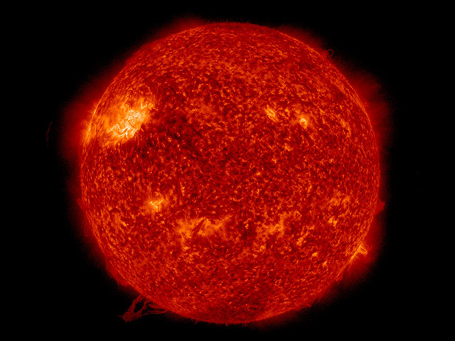
Picture credit: NASA

max_weisenfeld said:
Monday June 23
Hot. Very Hot
The NWS has issued a High Heat Warning for today and tomorrow and likely will issue an Air Quality Alert for today, and will likely issue one for tomorrow as well
A high pressure system brings temperatures around 100⁰ today and Tuesday with heat indexes near 110⁰. A very slight chance of a thunderstorm brings little promise of relief. Overnight lows both nights only down to the 70⁰s
Wednesday a cold front is likely to make things only slightly better with possible afternoon clouds, and a chance of showers and a thunderstorm. High mid 90⁰s
The cold front will move back and forth through the area during the back end of the week, lowering temps Thursday into the 80⁰s and Friday perhaps into the 70⁰s and bringing chances of showers and thunder each day. Overnight lows in the 60⁰s. The pattern right now looks like it could carry into the weekend
Picture credit: NASA
Great shot, rather ominous. Pretty sure they didn't shoot that with an I Phone.


Birds flying into the garden are panting so please put out water. I've just added cold water to the bird baths and fountains as they felt too warm. Deer appreciate it as well. During the last drought I had a doe walk over to the large fountain as I was filling it. Squirrels, raccoons, and the passing community cats are thirsty.
Even pots of cool water help.

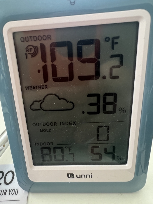
jamie said:
To be fair my sensor is directly in the sun
My sensor never gets sun since it hangs under the eave on the north side of our house, and it was a bit over 100 yesterday afternoon.
RECORD EVENT REPORT
NATIONAL WEATHER SERVICE NEW YORK, NY
1218 PM EDT TUE JUN 24 2025
...RECORD HIGH TEMPERATURE SET AT NEWARK LIBERTY INTERNATIONAL
AIRPORT...
A RECORD HIGH TEMPERATURE OF 100 DEGREES WAS SET AT NEWARK NJ TODAY.
THIS BREAKS THE OLD RECORD OF 97 DEGREES SET IN 1966.
THIS PRODUCT WILL BE UPDATED THIS AFTERNOON SHOULD TEMPERATURES
CONTINUE TO RISE.
RECORDS GO BACK TO THE YEAR 1931 AT THIS CLIMATE STATION.
ALL CLIMATE DATA ARE CONSIDERED PRELIMINARY UNTIL REVIEWED BY THE
NATIONAL CENTERS FOR ENVIRONMENTAL INFORMATION (NCEI).
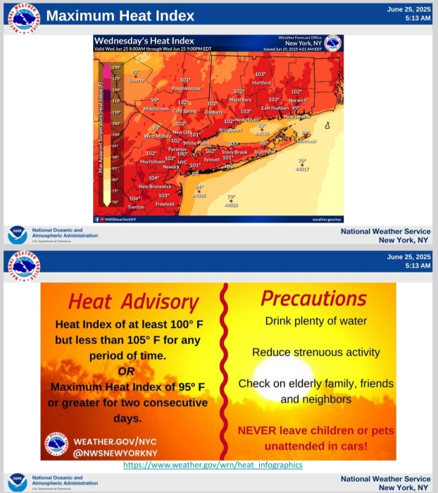
Wed June 25th
Last day of the heatwave, then cooler with showers
Today, the NWS has issued a Heat Advisory and an Air Quality Alert. Temps will be slightly cooler with highs in the mid 90⁰s and the air slightly less humid with a heat index "only" in the upper 90⁰s. Showers and a thunderstorm are possible this afternoon and evening, low around 70⁰
Noticeably cooler Thursday, high in the low 80⁰s with a chance of afternoon and evening showers, overnight low in the 60⁰s
Friday and the weekend continue the pattern with highs in the upper 70⁰s or low 80⁰s and chance of showers and possibly a thunderstorm. Overnight lows in the high 60⁰s
There is little chance of severe weather throughout the period

For Sale


Garage Sales
-

Maplewood Yard Sale! Sale Date: Jun 27, 2026
More info
Free Items
Rentals

Advertisement


Monday June 2
A sunny start to the week
Today, warm and partly cloudy this afternoon as the system moves off to the east. High low 70⁰s, overnight low mid 50⁰s
Tuesday clear and warmer. May see a bit of haze from wildfire smoke wafting in from Pennsylvania and Canada. High in the low 80⁰s low overnight around 60⁰
Wednesday and Thursday, welcome summer! Clear to partly cloudy, highs in the mid to upper 80⁰s, lows in the mid 60⁰s, chance of a shower Thursday afternoon
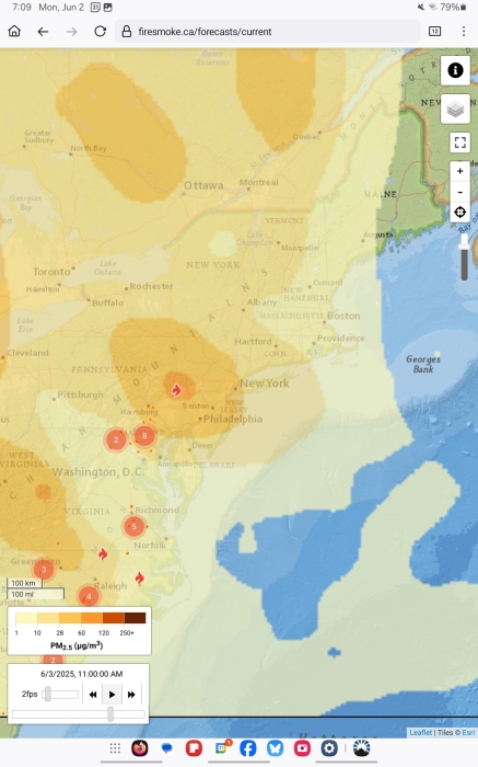
Pictured is a possible smoke situation tomorrow afternoon