Severe Thunderstorm Watch this afternoon and evening, Monday July 18th

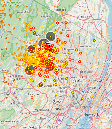
There's a whopper going on north of us right now. Check out this lightening map:


In order to add a comment – you must Join this community – Click here to do so.
For Sale
-

leather couches $300
More info


Garage Sales
-

Multi Family Garage Sale Sale Date: Apr 20, 2024
More info
Free Items

Sponsored Business


Promote your business here - Businesses get highlighted throughout the site and you can add a deal.

Severe Thunderstorm Watch this afternoon and evening, Monday July 18th
The NWS has issued a Severe Thunderstorm Watch for most of New Jersey. Thunderstorms will continue to develop and move through the area for the rest of the day. Any storm could present with strong gusty winds, lightening, and hail.
A Watch indicates that conditions exist for a weather event to happen. Please keep an eye on any alerts from your weather app or the NWS for a storm Warning, which would mean a severe storm is in the area or immanent. As always, please don't depend on me for timely warnings.
From the national weather service:
Severe Thunderstorm Watch
SEVERE THUNDERSTORM WATCH OUTLINE UPDATE FOR WS 473NWS STORM PREDICTION CENTER NORMAN OK145 PM EDT MON JUL 18 2022
SEVERE THUNDERSTORM WATCH 473 IS IN EFFECT UNTIL 1000 PM EDT FOR THE FOLLOWING LOCATIONS
NJC003-005-007-013-015-017-019-021-023-025-027-029-031-033-035-037-039-041-190200-/O.NEW.KWNS.SV.A.0473.220718T1745Z-220719T0200Z/
NJ. NEW JERSEY COUNTIES INCLUDED ARE
BERGEN BURLINGTON CAMDEN ESSEX GLOUCESTER HUDSON HUNTERDON MERCER MIDDLESEX MONMOUTH MORRIS OCEAN PASSAIC SALEM SOMERSET SUSSEX UNION WARREN