Cold Weather Advisory


tomcat said:
Can I put in a request for weather in the 60's?
Of course. Normal request processing time is, of course, 12-16 weeks.


Monday January 5th
The year begins with a slight chance of snow and then a late week warming trend
Today, slight chance flurries or light snow today, then overcast high lower 30⁰s, overnight low lower 30⁰s, too
Tuesday cloudy, a bit warmer, high near 40⁰, Tuesday night low mid 30⁰s Chance of a bit of rain
Wednesday and Thursday cloudy, warmer, high upper 40⁰s, thursday night chance of rain
Friday mid 50⁰s likely chance of rain
Saturday mid 50⁰s rain likely, breezy
Sunday chance rain, cooler


Please forgive the hot weather intrusion. Our continent is overrun by astonishing hot weather, and extreme fire warnings. These conditions haven’t been seen for years (since the awful Black Summer fire season) and are expected to last at least a week from today.
Marksierra will be sweltering in temps well over 100°F; I’ve heard that at least one day will be close to 113°. Nighttimes won’t bring much relief. Where I am, although the temperature readings will maybe hit 90°F, the humidity is often around 90% and the feels-like effect can be almost 100° by lunchtime. We’re not expecting rain for days; haven’t had any for almost a week.
Please cross your fingers, or whatever hopeful thing you do, that no-one dies of heat exhaustion, fires etc. Apparently only monsoonal rains and cyclones could break this weather.

oots said:
hopefully all white crap will be gone soon ❄️
Some curb cuts were still iced in today. Sidewalks are now mostly clear.
Wed Jan 7th
January thaw
Today, fog early, then partly cloudy and a bit breezy this afternoon. High in the upper 40s, overnight low near freezing
Thursday sunny, high upper 40s, low mid 30s. Chance of rain overnight
Friday, rain likely, breezy in the afternoon, high near 50, overnight rain likely low mid 40⁰s
Saturday rain likely, breezy, high mid 50⁰s, overnight breezy, rain tapers off near morning low mid 40⁰s
Sunday chance showers
Friday January 9th
There may be patches of black ice out there this morning
Today, mostly sunny, clouds gather towards evening, chance rain late. High mid 50⁰s overnight and a bit breezy, low around 40⁰
Saturday rain likely, particularly in the afternoon and overnight, may see some moderate to briefly heavy showers, cooler, high low 40⁰s, low temp about the same
Sunday may start with a shower then clearing, high mid 40⁰s low near freezing potential exists for black ice overnight, windy overnight with gusts in the 30-35mph range
Monday clear high near 40⁰, breezy
Monday Jan 12th
Today breezy, a bit colder, mostly sunny, high around 40⁰ then near freezing tonight
Tuesday more clouds, high in the lower 40⁰s, low overnight upper30⁰s
Then the forecast becomes difficult as a series of fronts move through Wednesday and Thursday. Temperatures are likely to drop through the period, and precipitation is chance to likely. Precipitation is more likely rain on Wednesday becoming more likely snow on Thursday through Thursday night, with a possible transition period of wintery mix in there somewhere. I will update if I can get more clarity but there is a high chance that we won't know what's coming until it falls from the sky. Most likely bad case scenario though is showers followed by a period of light wintery mix followed by a modest accumulating snow, an inch or so.
Friday and Saturday looking clear and reasonably cold
Sunday chance of snow showers


Tuesday afternoon update Jan 13th
The incoming cold front will bring the dry weather to an end by Thursday but not in any serious stormy way.
The models have come to some reluctant agreement that the storm some were seeing this week Wednesday/Thursday is not likely to happen. The system coming in from the Great Lakes region is not going to connect to the coastal/offshore system, at least not within hundreds of miles of here (see picture below for one version of the two systems missing each other)
Updated forecast:Tonight and Wednesday continue unseasonably warm (yes, this is unseasonable warm) with highs Wed nearing 50 and a slight chance of light rain.
Overnight Wed - Thurs chance of light rain low dropping down near freezing around dawn so watch out for mixed light to moderate rain and snow or sleet and possibly black ice Thursday early morning
Thursday morning light rain or snow showers possible, ending around lunchtime. Then clearing and colder, high around freezing will likely happen mid morning then temps will resume dropping. Overnight low in the teens
Friday dry and cold, high near 30.
Might see some rain or snow over the weekend, though again not likely any great amount of either.

Thursday January 15th
Nothing last night, maybe a little bit this weekend
Models are coming into alignment on the forecast for this weekend, and as they do the snow signal, not particularly strong to begin with, has faded a bit
Today, breezy and gusty as the clouds clear and the temperature drops. We've already seen the high for today and the thermometer is now dropping as the winds pick up. Daytime lows in the mid 30s and overnight into the lower 20s with wind chills in the single digits near dawn
Friday, colder and clear, breeze but likely not as gusty as today. Friday high lower to mid 30s, overnight low mid 20s, slight chance of light snow in the wee hours
Saturday, chance of light snow followed by a chance of rain as temps start out in the mid 20s but rise during the day to a high in the low 40s
Sunday, chance of snow, high mid 30s low lower 20s

We’re gonna get snow for one day out of the weekend? Say it’s light snow on Saturday, we’re gonna get much more snow on Sunday? It’s sounding like if we get a lot on Saturday then the system moves off shore, and no snow on Sunday. But it could go both ways? I know it’s a difficult forecast for this weekend. Just curious because there seems to be two systems that might join or stay solo. Either way it’s gonna be very cold.
Some of out bigger storms have been on MLK jr day or Presidents’ Day. I still remember’93 and ‘96 with back to back blizzards.
Friday January 16th
A bit of snow this weekend, then cold again
Today, sunny, high mid 30⁰s
Overnight, clouds move in and a chance of light snow overnight, low upper 20⁰s
Saturday light snow likely, probably less than an inch, likely changing over to light rain in the afternoon as temps reach the upper 30⁰s. There is a slight upside potential but even so accumulation should be minor
Saturday night chance to slight chance light rain or snow, low around 30⁰
Sunday mostly cloudy, slight chance of a lingering light snow, high mid 30⁰s
MLK Day clear, dry, mid 30⁰s high, overnight low mid teens
Tuesday clear, cold, low 20⁰s
Jaytee said:
We’re gonna get snow for one day out of the weekend? Say it’s light snow on Saturday, we’re gonna get much more snow on Sunday? It’s sounding like if we get a lot on Saturday then the system moves off shore, and no snow on Sunday. But it could go both ways? I know it’s a difficult forecast for this weekend. Just curious because there seems to be two systems that might join or stay solo. Either way it’s gonna be very cold.
Some of out bigger storms have been on MLK jr day or Presidents’ Day. I still remember’93 and ‘96 with back to back blizzards.
As of this morning there is a wide consensus among the models keeping the bigger storm offshore and New Jersey barely in the northwest outflow. No MLK blizzard this year


Are we getting snow tonight into tomorrow? It sure feels like the humidity is in place. We might get a little break tomorrow afternoon and back at it again for Sunday.??? Is it still a hit or miss type thing? I’m happy I have my snow blower ready to go.

Snow was not too hard to clear. More snow is forecast for tomorrow but I wanted to move what I could.
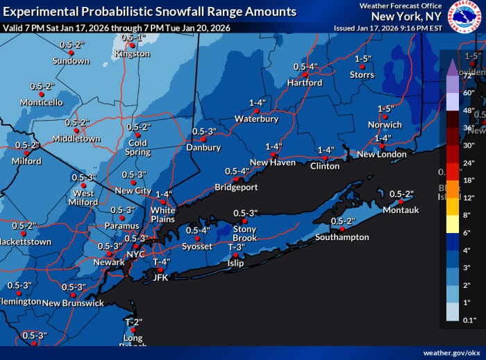
Saturday night Jan 17th update
The NWS has posted a Winter Weather Advisory for Sunday. Advisory details below.
The NWS is also concerned about black ice tonight where wet roads may freeze.
Sunday, periods of snow, 2 - 4 inches likely by evening. Snow should arrive before 7am (may start out with a bit of mixed rain and sleet before turning to all snow for the rest of the day). Periods of snow likely to continue on and off for the rest of the day, tapering off before midnight. Daytime temps around freezing, overnight low lower 20s.
Monday mostly clear with breezy, high around freezing.
Monday night temps will likely drop into the mid teens, starting a cold snap.
Tuesday temps should barely hit the low 20s and overnight low teens are expected.
Just a note about Saturdays -- I have a volunteer gig at the high school every Saturday from now through mid-march that means I don't have time or access to do the weather, so if we get another day with short term changes please forgive me but I won't be able to post.
315 PM EST Sat Jan 17 2026

...WINTER WEATHER ADVISORY REMAINS IN EFFECT FROM 7 AM TO 8 PM EST
SUNDAY...

* WHAT...Snow expected. Total snow accumulations between 2 and 4
  inches.

* WHERE...Portions of southern Connecticut, northeast New Jersey,
  and southeast New York.

* WHEN...From 7 AM to 8 PM EST Sunday.

* IMPACTS...Plan on slippery road conditions.

PRECAUTIONARY/PREPAREDNESS ACTIONS...

Slow down and use caution while traveling. Check local Department of
Transportation information services for the latest road conditions.

max_weisenfeld said:
Saturday night Jan 17th update
The NWS has posted a Winter Weather Advisory for Sunday. Advisory details below.
The NWS is also concerned about black ice tonight where wet roads may freeze.
Sunday, periods of snow, 2 - 4 inches likely by evening. Snow should arrive before 7am (may start out with a bit of mixed rain and sleet before turning to all snow for the rest of the day). Periods of snow likely to continue on and off for the rest of the day, tapering off before midnight. Daytime temps around freezing, overnight low lower 20s.
Monday mostly clear with breezy, high around freezing.
Monday night temps will likely drop into the mid teens, starting a cold snap.
Tuesday temps should barely hit the low 20s and overnight low teens are expected.
Just a note about Saturdays -- I have a volunteer gig at the high school every Saturday from now through mid-march that means I don't have time or access to do the weather, so if we get another day with short term changes please forgive me but I won't be able to post.
315 PM EST Sat Jan 17 2026

...WINTER WEATHER ADVISORY REMAINS IN EFFECT FROM 7 AM TO 8 PM EST
SUNDAY...

* WHAT...Snow expected. Total snow accumulations between 2 and 4
  inches.

* WHERE...Portions of southern Connecticut, northeast New Jersey,
  and southeast New York.

* WHEN...From 7 AM to 8 PM EST Sunday.

* IMPACTS...Plan on slippery road conditions.

PRECAUTIONARY/PREPAREDNESS ACTIONS...

Slow down and use caution while traveling. Check local Department of
Transportation information services for the latest road conditions.
Nobody should blame you for anything. What you do for all of us is great, to whatever extent you can do it!
(Are you building sets??)

Max, what’s the deal with next Sunday? Weather.com is talking about fairly heavy snow
Monday, Jan 19th
Cold week ahead
Tonight clouds clearing and temps dropping into the teens, breezy with wind chills in the single digits likely
Tuesday clear, cold, and breezy. High near 20⁰, wind chills in the single digits, overnight lows in the single digits with wind chill near zero
Wednesday should be a bit more seasonal, high gets up near freezing after a very cold morning. Afternoon cloudy, breezes may chill things a bit, overnight low still likely to be around 30⁰
Thursday the warmest day this week with a high near 40⁰, mixed sun and clouds, still breezy, overnight low in the mid 20⁰s
Friday cooler, mostly cloudy, high upper 20⁰s
The weekend is still TBD, the models are hinting at a Winter Weather event but without any clarity so for now I'll hold off on any predictions other than prepare for cold weather
max_weisenfeld said:
sac said:
(Are you building sets??)
Yes
Does this mean the play will be at the high school?
yahooyahoo said:
max_weisenfeld said:
sac said:
(Are you building sets??)
Yes
Does this mean the play will be at the high school?
yes
Wed 1/21
Some thoughts about the weekend and snow
First, a word from the NWS: "Confidence is increasing in the potential for a significant winter storm to impact the area Sunday into Monday with accumulating snowfall."
The models have been in increasing agreement for the last 24 hours, but there is a caveat...the centers of energy for this storm are in part still out over the Pacific Ocean this morning, and therefore are not getting sampled and measured in as much detail or as often as they will when they come ashore later today and tomorrow. It is still about 5 days out. That's a long time with a complex system.
With that, some things are fairly certain. We expect a large arctic air mass to be overrun by a deep moist subtropical system. The interaction between these is one of the things the forecasters need better data to model. That said, a storm impacting the continental US is likely, with winter precipitation from Texas to the Mid Atlantic. As it affects us here, the cold air makes it likely that whatever snow we get will tend to be dry and light (in weight) and therefore deeper than what we got last weekend. There is a slight signal for possible sleet at the end.
The models are also signalling the potential for this to be a long storm, with snowfall starting Sunday morning and running for 24 hours or more. It is likely to be very cold for much of the duration of the storm. At this time blizzard conditions (heavy snowfall and wind-blown snow) do not look likely, as the winds look moderate.
If the storm center moves north of the current consensus track we could see more sleet and less snow depth.
So. The potential continues to increase that we will have a significant winter storm, most likely Sunday into Monday. The current models indicate a 50%-70% chance of 6" or more in our area. There is noticeable upside potential (over 6") but it's too soon to say with much confidence how much more. There is no point in me updating until tomorrow afternoon at the earliest, by which time there will be better data in the models.
Ok so I can look like a mensch and volunteer for car pool duty on Monday, knowing there is a good chance school gets canceled.


Thursday Jan 1
A cold front dragged a snow squall through the area early this morning leaving about an inch of new snow. Otherwise we are in for a few days of cold and dry weather
Today we are already at the forecast high of 29. Blustery conditions today under mostly clearing skies. Gusts in the low 30mph range until this evening so expect significant wind chill. Overnight lows in the high teens likely
Friday mixed sun and clouds, breezy, high near 30, low in the low 20s
Saturday increasing clouds, high near freezing, low in the lower 20s
Sunday, slight chance of a little snow (only showing up in the experimental AI models as of now), otherwise sunny, high in the mid 30s, low around 20