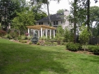
Maplewood, neighborhood backyard at Parker, Baldwin, Berkshire, Burr

Interesting. It shows up as its own lot on the tax map for the neighborhood. Completely locked in as you say.
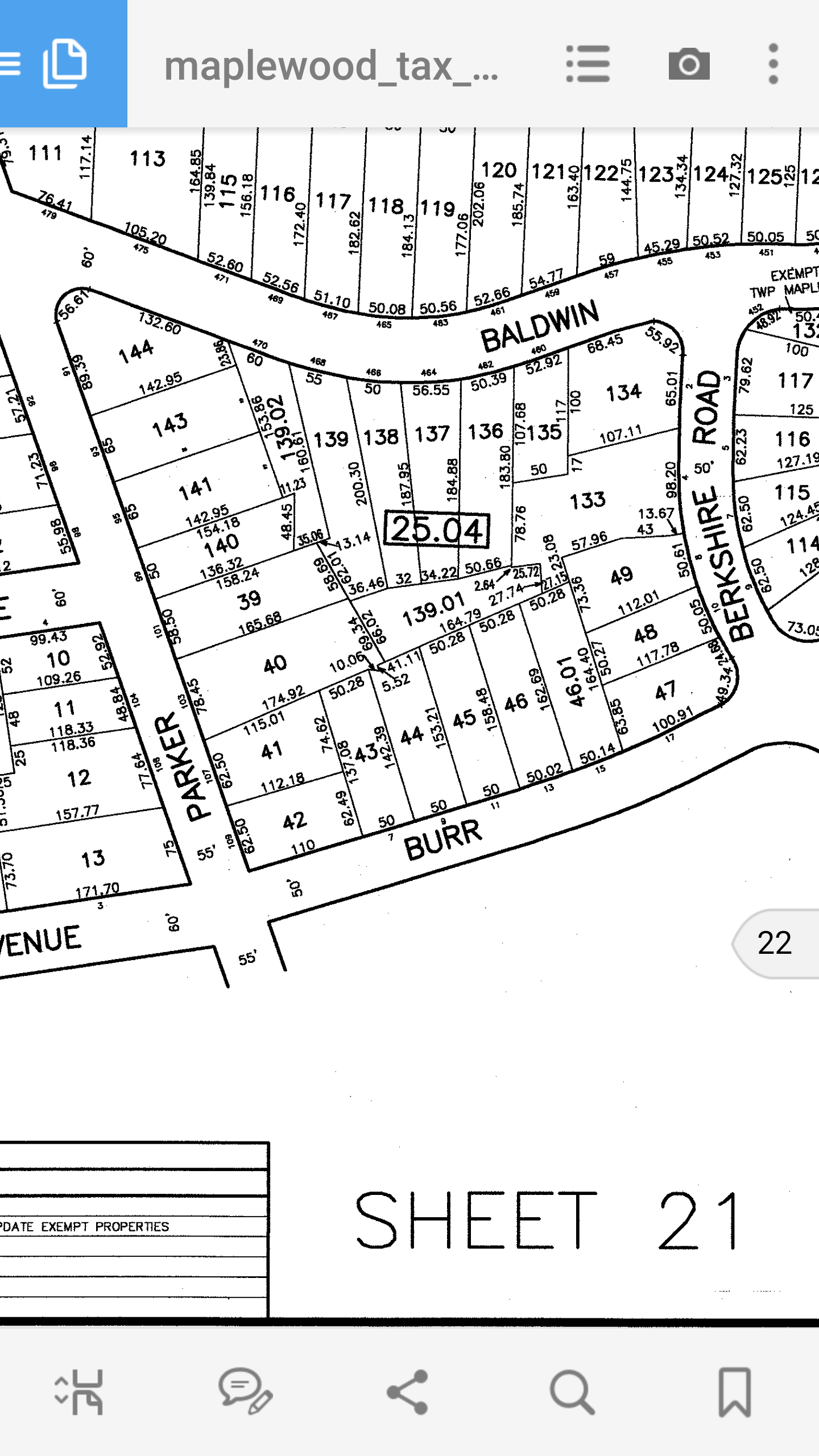
It's owned by the people who own an adjacent lot at 103 Parker. I just searched the block and lot information.

Interesting. Further down at the intersection of Parker and Boyden a small "park" shows up on my iPhone map at the end of Briarcliff Court. It is surrounded by homes on Briarcliff, Garfield Place, Boyden, and Parker. I found a map once that referred to it as Olympic or Olympia Park. But if I look at the tax map, there are three houses on Parker that have very deep backyards that occupy the same space. I've never been able to figure out if there was a park there in the past or its just an anomaly.


mrincredible said:
It's owned by the people who own an adjacent lot at 103 Parker. I just searched the block and lot information.
Odd that it is a separate lot. In regards to playing there, I guess my friend was just trespassing then 
Zillow shows the home as being built in 1810, but I believe I was told it was actually older, around the late 1700’s.
My mom actually used to know the couple who lived in the house back in the early 90’s. They had renovated it, and then one half of the couple suddenly fell ill and then passed away from a brain tumor, the other half moved away shortly after
yahooyahoo said:
Interesting. Further down at the intersection of Parker and Boyden a small "park" shows up on my iPhone map at the end of Briarcliff Court. It is surrounded by homes on Briarcliff, Garfield Place, Boyden, and Parker. I found a map once that referred to it as Olympic or Olympia Park. But if I look at the tax map, there are three houses on Parker that have very deep backyards that occupy the same space. I've never been able to figure out if there was a park there in the past or its just an anomaly.
I just looked it up on Zillow and they show the same green area, but they also show the property lines extending back to their neighbors. That is weird
I wonder how many other little oddities around town there are.
That orphaned lot spontaneous was talking about it a curiosity indeed. I wonder if someone purchased the lot many years ago for the express purpose of creating a space that couldn't be developed? The folks who currently own it pay about a grand in taxes every year.
Just in that map there are some funky property lines ... Lot 139 seems to have two sublots ... 139.01 and 139.02. Then Lot 133 has some strange borders.


I thought that Olympic Park was on the Irvington Border near Seth Boyden School (?)
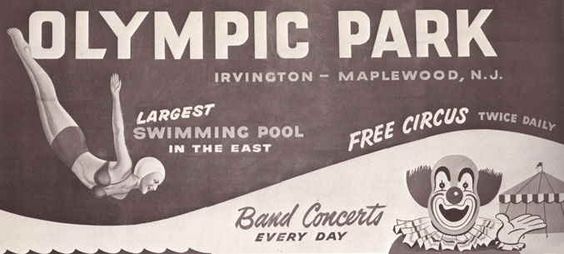
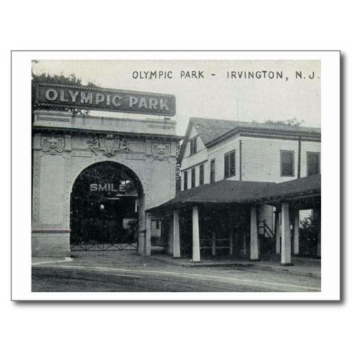
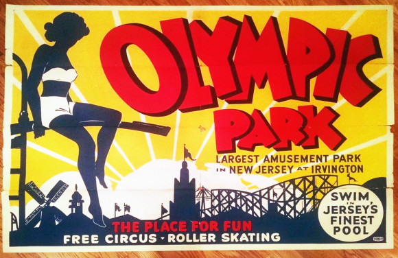
There's an Olympic Park in Irvington between 40th and Coolidge across from International Vitamin Co. I think it's a remnant of the former Olympic Park which was an amusement park over there that straddled what is now Irvington and Maplewood. It was in a space that's now full of warehouse type buildings. If you look at Chancellor Ave there is a street called Camptown ... that runs down the middle of what used to be the amusement park. It had a big swimming pool and a bunch of rides. It closed in 1965.
If you ever have ridden on Prince Charming's Carousel in Disney World, you have ridden on a piece of NJ history. That was the carousel at Olympic Park.
http://lostamusementparks.napha.org/Articles/NewJersey/OlympicPark.html

sac is correct about Olympic Park.
yahooyahoo said:
Interesting. Further down at the intersection of Parker and Boyden a small "park" shows up on my iPhone map at the end of Briarcliff Court. It is surrounded by homes on Briarcliff, Garfield Place, Boyden, and Parker. I found a map once that referred to it as Olympic or Olympia Park. But if I look at the tax map, there are three houses on Parker that have very deep backyards that occupy the same space. I've never been able to figure out if there was a park there in the past or its just an anomaly.
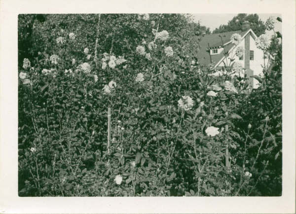
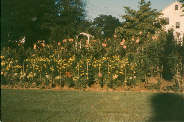
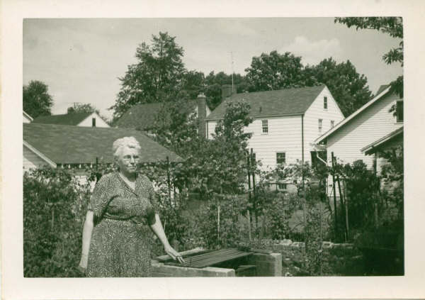
Consider me your local expert on this area. I lived at the corner of Parker and Boyden for 20 years. Back in 2009 I got an email out of the blue by a Pennsylvania woman who was interested in the house because her grandparents lived there in the 1950s and she had spent a lot of happy times with them. I invited her over for a tour, and she shared some photos.
The three lots with the very deep backyards were part of the parcel where 191 Parker sits. The previous owners had used the very big lot as a sort of suburban farm, from which they ran a cut flower business. As they got older, and property taxes got more prohibitive, the subdivided the big lot and sold off three parcels where the three split-levels now sit.
More here: http://tom-mcgee.com/archives/1911
You can see identify the houses in the backgrounds of these photos. 183 Parker Ave., 43 Boyden Ave., and 45 Boyden Ave.
Thanks Tom, that's great stuff. I always like stories about how things used to be around town.
Here is a screenshot from Mapquest that I grabbed today. You can see the green area enclosed by the four streets and, for some reason, they call it Olympic Park.
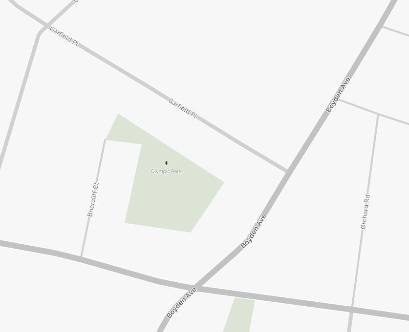

Yahoo squared that's very interesting. Looking on the Google satellite view, that area is a wooded patch that looks like it could very well have been a park. But it's nowhere near the historical Olympic Park down behind Seth Boyden. It seems like an interesting little mystery. Now curious to find some older maps of that area to see if there's any reference to an Olympic Park that is no longer there.

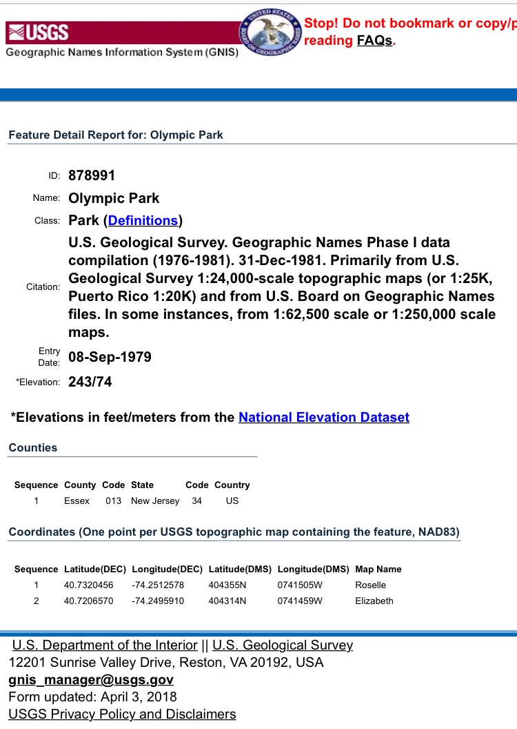
The USGS has it as a defined location in the same spot between Parker and Garfield.
Okay I may or may not have driven down Briarcliff Ct on my way home to try and take a peek.
If I HAD I would have seen that there was no indication of a park having been there.
mrincredible said:
There's an Olympic Park in Irvington between 40th and Coolidge across from International Vitamin Co. I think it's a remnant of the former Olympic Park which was an amusement park over there that straddled what is now Irvington and Maplewood. It was in a space that's now full of warehouse type buildings. If you look at Chancellor Ave there is a street called Camptown ... that runs down the middle of what used to be the amusement park. It had a big swimming pool and a bunch of rides. It closed in 1965. If you ever have ridden on Prince Charming's Carousel in Disney World, you have ridden on a piece of NJ history. That was the carousel at Olympic Park. http://lostamusementparks.napha.org/Articles/NewJersey/OlympicPark.html
Yes, I had heard about that. The one time we took our kids to Disney was when they were in Kindergarten and 4th grade at Seth Boyden (Spring Break of 2001) and we made sure to tell them about it when we rode that Carousel.

TOM: is the house that is diagonal on the lot (corner of Parker and Boyden) the original house for the suburban flower farm? It looks like a 1900-1920s bungalow - maybe Sears or Montgomery Ward kit house?
tom said:
sac is correct about Olympic Park.
yahooyahoo said:
Interesting. Further down at the intersection of Parker and Boyden a small "park" shows up on my iPhone map at the end of Briarcliff Court. It is surrounded by homes on Briarcliff, Garfield Place, Boyden, and Parker. I found a map once that referred to it as Olympic or Olympia Park. But if I look at the tax map, there are three houses on Parker that have very deep backyards that occupy the same space. I've never been able to figure out if there was a park there in the past or its just an anomaly.
Consider me your local expert on this area. I lived at the corner of Parker and Boyden for 20 years. Back in 2009 I got an email out of the blue by a Pennsylvania woman who was interested in the house because her grandparents lived there in the 1950s and she had spent a lot of happy times with them. I invited her over for a tour, and she shared some photos.
The three lots with the very deep backyards were part of the parcel where 191 Parker sits. The previous owners had used the very big lot as a sort of suburban farm, from which they ran a cut flower business. As they got older, and property taxes got more prohibitive, the subdivided the big lot and sold off three parcels where the three split-levels now sit.
More here: http://tom-mcgee.com/archives/1911
You can see identify the houses in the backgrounds of these photos. 183 Parker Ave., 43 Boyden Ave., and 45 Boyden Ave.
Yes, it is the original house. I don't think it was a kit house -- I never saw any of the identifying marks on the joists. It was built in the early '20s.

I remember that space too. Since the yards in that area were teeny it was very nice to have.

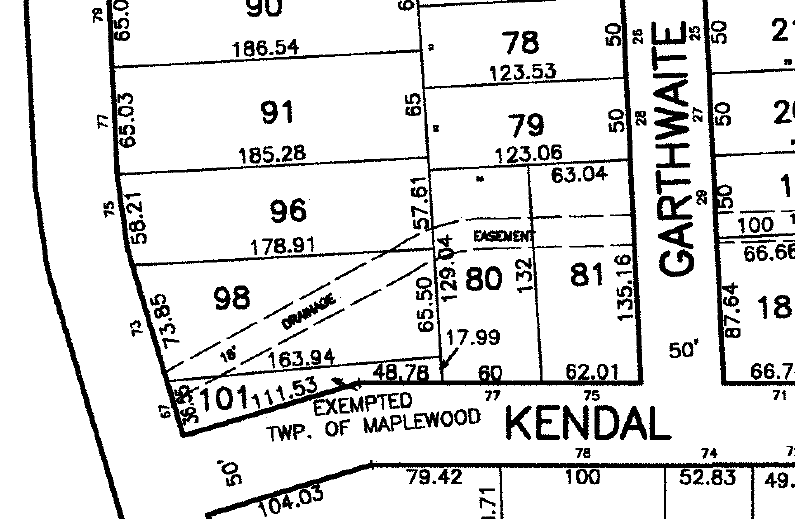
There are many such oddities in the tax maps. Two attached. At the corner of Jefferson and Kendal, the land on the northwest corner appears to be part of the property next to it, but in fact belongs to the town. Near the corner of Garfield and Burr Road, across from Underhill Field, there is a small, useless triangle of land behind the houses that also belongs to the town.
Is there online access to these tax maps?
P.S. Never mind, found it.
elvis said:
There are many such oddities in the tax maps. Two attached. At the corner of Jefferson and Kendal, the land on the northwest corner appears to be part of the property next to it, but in fact belongs to the town. Near the corner of Garfield and Burr Road, across from Underhill Field, there is a small, useless triangle of land behind the houses that also belongs to the town.
Kendall has been rerouted. You can see on some of the older maps that it didn't go through to Jefferson. Instead it curved to the east and ran into Walton.
If you walk around there you can see curve cuts that indicate where the old road had been.
yahooyahoo said:
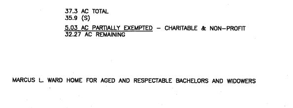
Look at the name for Winchester Gardens on the tax map:
I don't qualify as a bachelor and hope to never be a widower! I do hope to be aged, not sure about respectable.

mrincredible said:
yahooyahoo said:I don't qualify as a bachelor and hope to never be a widower! I do hope to be aged, not sure about respectable.
Look at the name for Winchester Gardens on the tax map:
I am aged, a bachelor and I can lie about being respectable. Who do I see?
yahooyahoo said:
Look at the name for Winchester Gardens on the tax map:
There is an article in this month's Matters magazine about the history of Winchester Gardens. I think the article said women weren't allowed until the 1980s.
yahooyahoo said:
Is there online access to these tax maps?
P.S. Never mind, found it.
For everyone else's benefit
Rentals
Sponsored Business


Promote your business here - Businesses get highlighted throughout the site and you can add a deal.

When I was young I had a friend on Baldwin Rd in Maplewood. In the back yard they would go through the fence to a little area that was shared by all the yards. Looking at google maps this area does not seem to belong to any of the homes there, it appears to be separate.
It isn't like the little park on DeHart Rd, that one has an entryway to the street. The small area on Baldwin/Burr is completely land locked
Was this done on purpose for all the yards to share? Was it an accident when they divided up the plots?